Navionics® Boating is a must-have app for boaters, anglers, and sailors who value precision and convenience while on the water. Designed with advanced features and user-friendly tools, this smartphone application transforms your mobile device into a powerful navigation system. The best part? You can experience its full capabilities with a free trial for a limited time.
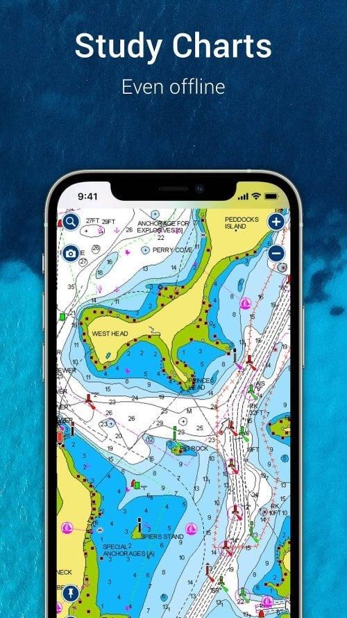
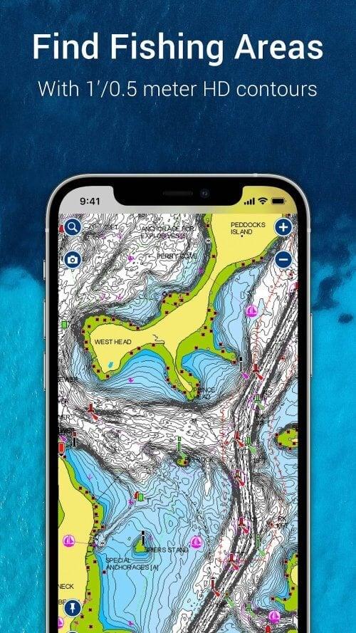
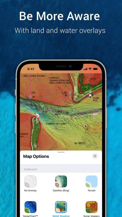
Powered by world-class Navionics charts, the app delivers highly detailed maps above and below sea level, giving you an accurate representation of your surroundings. Whether you're navigating narrow channels or searching for the perfect fishing spot, SonarChart HD bathymetry maps offer exceptional clarity of underwater terrain, helping you make informed decisions.
Beyond its mapping excellence, Navionics® Boating fosters a vibrant and interactive community. Share insights, discover hidden gems, and connect with fellow boaters around the globe. You can also share real-time location data, routes, and markers with friends, making group excursions more coordinated and enjoyable.
The app supports integration with external devices, expanding your navigation toolkit. Seamlessly transfer routes and markers between your smartphone and compatible chartplotters. With SonarChart Live Mapping, create custom depth maps in real-time as you explore new waters. And when connected to a compatible AIS receiver via Wi-Fi, you gain access to live maritime traffic information and collision alerts—enhancing safety during every voyage.
To ensure optimal performance and accuracy, Navionics® Boating receives daily updates. These updates reflect the latest changes in water depths, navigational hazards, aids to navigation, and local services, so you always have the most current data at your fingertips.
Key Features of Navionics® Boating:
* World-Class Charting Tools:
Access comprehensive Navionics charts that include nautical overlays, high-resolution bathymetric maps (SonarChart HD), and satellite imagery. These tools provide critical insights for safer and smarter navigation.
* Engaged Community Experience:
Become part of a global network of water enthusiasts. Exchange tips, mark popular spots, and follow real-time updates from other users. Stay connected with friends by sharing your position, tracks, and planned routes effortlessly.
* Compatibility with External Devices:
Enhance your onboard system by syncing with compatible chartplotters, enabling seamless route and marker transfers. Use SonarChart Live Mapping to generate dynamic underwater maps while underway. Pair with an AIS receiver to monitor nearby vessel traffic and receive proximity alerts.
* Daily Content Updates:
Benefit from regular updates that keep your charts and points of interest current. From shifting sandbars to updated marina locations, you'll always have reliable data guiding your journey.
Final Thoughts:
Navionics® Boating is more than just a navigation app—it's an indispensable companion for anyone serious about life on the water. With precise charting, real-time sonar mapping, and a thriving user community, it empowers you to explore confidently and efficiently. Its compatibility with marine electronics adds another layer of functionality, while daily content updates guarantee accuracy throughout your adventures.
Whether you're cruising, fishing, or sailing, Navionics® Boating equips you with everything you need to enhance your time on the water. [ttpp]Download now and start exploring smarter with [yyxx].